You are using an out of date browser. It may not display this or other websites correctly.
You should upgrade or use an alternative browser.
You should upgrade or use an alternative browser.
Let them eat cake.
- Thread starter Paul
- Start date

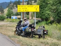
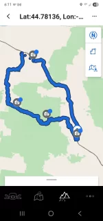
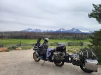
Yesterday was another short day. After leaving Lolo pass we continued west on US12. It's surprising what you see running the speed limit through there. Stopped in Kooskie for lunch. Then south on SR13. I'm pretty sure I was reading the license plate on the trailer through a couple corners. We called it at a small mom and pop motel in Grangeville.
Attachments
Friday the 13th finds us riding south on US95 out of Grangeville, ID. Plan was to ride the old Whitebird hill but it was starting to rain and I missed the turn. Anyway we continued south to Cambridge. Stopping in old stomping grounds where I met my wife in highschool a long time ago.
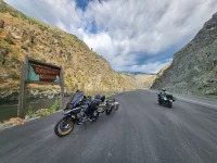
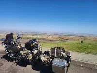
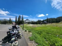
Meanwhile back at the ranch. We turned in Cambridge heading to Oxbow, OR through Hells Canyon. The Idaho side has several miles of tight 25 mph corners with steep drop offs. Temps hit 90° and the sun was relentless. We made it to Baker city and called it a night.
2 points for telling what the black and white photo is.
Attachments
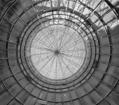
Good guess but not a Blimp hanger.Those are some seriously great pix.
The boxer rider looking back at the GS+ADV1? <marketing swoon>
Now about that blimp hangar or whatever pic...
My guess is an abandoned grain silo?
Abandoned grain silo with some bird nests?
2 points for telling what the black and white photo is.
Abandoned grain silo with some bird nests?
Close but no cigar.My guess is an abandoned grain silo?
Abandoned grain silo with some bird nests?
I've been sleeping with the RS rider for 40 years. So yes we've talked about the ADV1.Was there a convo with the RT rider about the ADV1?


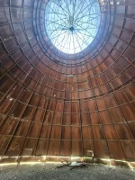
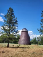
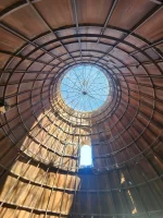
Years ago these burn towers were at every saw mill. There was a conveyor that would that would load the burner with the scraps of wood that was not worthy of making lumber. Today these jackets are chipped and used in many different ways.
Attachments
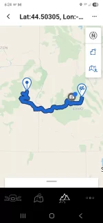
From Baker City, OR Sharon wanted to run over to Pendleton. We took the freeway afterwards ran 395 south and started wandering through mountain roads back towards Baker City. The plan was gas, eat and head to Ontario. We had enough daylight to make by freeway. But where's the fun on that. After deciding a route and the food coma setting we went back to the same motel as the night before.
Attachments
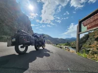
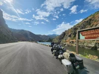
Baker City to Challis. We find ourselves doing a bit of backtracking today as I missed one turn and then a paved road turned to gravel and The RS gets a bit too squirrelly for what looked to be 70+ miles of gravel. From Baker south on 7 to 245. This is best described as a paved BDR. Narrow, steep 6-8% grades 2 lane no shoulders and twisties. Sound fun? Now let's add lots of pea gravel in EVERY corner. No gaurd rails with steep drops for several hundred feet.
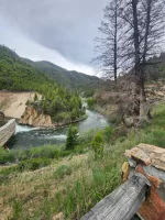
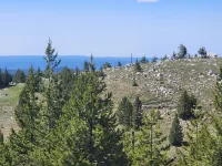
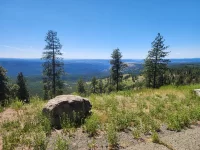
There were a few corners that I went too fast around that the bike was fine but the trailer would catch some gravel and slip a couple inches. Talk about butt pucker. We didn't die so it's OK. As we got off the mountain then it was onto US26 into Ontario. We succeeded in making a 78 mille trip onto 144 miles. Now onto Challis Idaho. It's Father's day and traffic on ID55 from Horse Shoe Bend to the Banks turn off 18 miles. Southbound was not moving at all. Thankfully we were heading north. Then East coming into Stanley we see the Sawtooth mountains. They can be easily mistaken for the Tetons.
There were a few corners that I went too fast around that the bike was fine but the trailer would catch some gravel and slip a couple inches. Talk about butt pucker. We didn't die so it's OK. As we got off the mountain then it was onto US26 into Ontario. We succeeded in making a 78 mille trip onto 144 miles. Now onto Challis Idaho. It's Father's day and traffic on ID55 from Horse Shoe Bend to the Banks turn off 18 miles. Southbound was not moving at all. Thankfully we were heading north. Then East coming into Stanley we see the Sawtooth mountains. They can be easily mistaken for the Tetons.
Attachments
There were a few corners that I went too fast around that the bike was fine but the trailer would catch some gravel and slip a couple inches.
Gorgeous pictures! And you're right...they do look like the Tetons.
I've never experienced the trailer slipping but not the bike. When the trailer caught, what happened? Did it impact the line through the curve?
Thanks for continuing to share your trip!
Rod
Tony D.
Beta Tester
Great pix, what mapping software are you using?
I've done a couple hun miles on gravel roads, not riding aggressively, and never noticed any slippage.
I was just headed up ID7 and met a guy coming down on a HD bagger. He said "Don't go up there, it's too twisty!" He had turned back after a mile.
His loss, it's a great road. Scary AF, but great.
I've done a couple hun miles on gravel roads, not riding aggressively, and never noticed any slippage.
I was just headed up ID7 and met a guy coming down on a HD bagger. He said "Don't go up there, it's too twisty!" He had turned back after a mile.
His loss, it's a great road. Scary AF, but great.